Get Out of Hanoi
Trying to get out of Hanoi and then get back in is often seen as the most challenging part of a bike trip. In fact, it can be and there are a few little gems of advice that will make things a lot easier.
You will also find detailed routes and descriptions, which will help you choose the right route for you. That’ll make your entry and exit from Hanoi almost as smooth as if you’d joined one of our professional motorcycle tours!
Factors affecting your choice
There are several factors that can affect your choice of route and when you leave. Here are some considerations, in no particular order. You may have one or two more.
Destination
Of course, this is the first and often the only factor that will influence your decision. You will generally know if you are heading North, South, East or West, however, on the odd occasion you might choose to head a little in the ‘wrong’ direction for some good reason. Remember though, ‘Every path is the right path.‘
Time of Day
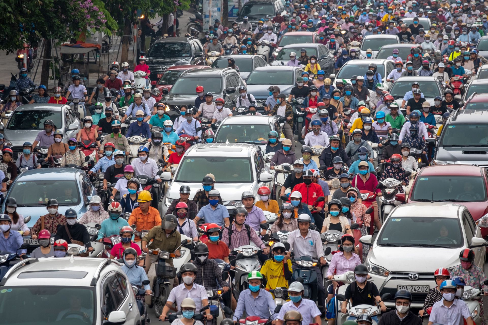
You definitely do not want to leave or return to Hanoi at rush hour unless you are accustomed to this kind of traffic. Even if you are used to it, being loaded or having saddle bags makes things a lot trickier and frustrating. That’s not a good way to begin or end a trip.
Morning Rush Hour: usually between 7am to 9pm
Afternoon Rush Hour: from around 5pm to 7pm
Unless you really have to do so driving anywhere at Dusk is not recommended.
The reasons for this are:
The changing light can mean that you misjudge distances and speeds. You may even forget that you are wearing sunglasses until everything gets very dark, very quickly.
As the sun sets, more and more insects will come out to play. This can be bothersome and when you already have tired eyes, the addition of an insect is usually both unwelcome and painful.
Specific Route
You know yourself what kind of road you and your group members prefer. Easier quieter roads for the less experienced? Faster highways with more traffic (and trucks), more manageable by the more experienced?
Experience Level
Similar to above, you are going to need to choose the correct route dependent on the level of the least experienced driver in the group. Bear in mind that this might be quite different on the return journey as riders gain skill.
How long (km, hrs) your first day is
Well, how far do you need to get in that first day? It is usually a good idea to have an easy day on the first day so that you can leave after morning rush hour and still make it to your destination for pre-dinner beers.
Equally, you don’t want your last day to be a ‘Hell Day’ so that you are forced to drive back into Hanoi in rush hour or in the dark. This is no good for newer, less experienced drivers.
You should also be aware that after a long drive, particularly on a cold, wet day, You are going to be less capable of dealing with the transition from country roads to town roads and traffic.
Number of Riders
The thing about a group is that you have more opinions and skill levels to deal with. Group decisions need to be taken and must factor in every rider. All this probably means that it is going to take longer to make a choice unless you all agree to have 1 route master who dictates the route of the day.
Another option is to have several small groups set out and make their way to your destination. This way, like minded riders can group together and get the most out of their trip. The above still holds true but then only on a smaller scale.
Weather
If it is a cool, dry, autumn day, you might want to take a longer, more scenic route. Generally speaking, you will, because you are on holiday and that it what bike trips are about, right?
If it is scorching hot or pouring with rain, you might choose to take a shorter route to get where you need to go quickly. You will not be stopping much for photos so it’s all about getting there.
Routes
In order to not get too detailed, I have begun these routes from paces outside the main city. Therefore, you need to figure out how to get to the start points indicated. It is usually quite simple. The general level of traffic on these roads can be considered to be ‘congested’ city traffic and is possibly the trickiest driving you will have to do.
For simplicity the city is broken up into North, South, East and West. This should help you get to the route taking the direction you need.
You will find that there is often a clear cut choice of route to take you out of the city or that there is the choice of two, but never more.
North
There are 3 main routes to get in / out of Hanoi to visit the North. You will be eventually linking up with the QL1, QL2c and the QL3. For each of these routes you will have a choice of which bridge to cross the Red River on.
If you are going North, you are heading for places such as: Tuyen Quang, Ha Giang or Thai Nguyen, Ba Be, Cao Bang or perhaps even Lang Son, which we include here even though it is a bit East.
QL 1a
This is the road that you want to be on to get to Bac Son or Lang Son and then up to Cao Bang. You can cross any one of the bridges: Long Bien, Chuong Duong, Vinh Tuy or Thanh Tri, and your choice depends mainly on where you live but also other factor (listed above).
The easiest route is to take Chuong Duong Bridge and keep going straight. It is not the fastest route and there is some traffic but you do not need to navigate. You just go straight. You could, if you want, take this bridge or the Long Bien Bridge and then turn left to get on to Ngoc Thuy. This alternative route is a bit longer but has less traffic and so is a bit easier to drive.
If you are not too concerned by traffic then getting over one of the three lower bridges: Chuong Duong, Vinh Tuy or Thanh Tri, will allow you to get on to AH14 and QL1a very quickly and you will make very good time out of town. This is very useful if you plan to go all the way to Cao Bang via this route; you can be in Lang Son for an early lunch.
QL2c
If you are heading directly North and up to Tuyen Quang and Ha Giang, then you are best off getting on the QL2c. You can use either Nhat Tan or Thanh Long Bridge to do this but generally Nhat Tan is a much easier drive. The road to and across the Thanh Long Bridge is very congested and has lots of trucks on it.
You head out over Nhat Tan Bridge and just keep heading straight. After around 15km the road will turn to left and you will go past the airport on your right. Be careful here as there are often cops hanging out at speed traps; stick to 40kmh until you are past the airport. You will then come to a crossing and small roundabout go straight over this and keep heading westward on the QL2a.
Do not turn right onto the CT05 as you are not allowed on this road. There is a toll there and they will not let you through anyway. You simply follow this road and go under the CT05 and head for Ba Hien. You will join up with the DT310b and then DT310 and from there you can follow the mountain ridge to you right as the QL2c takes you up to Tuyen Quang.
You will note that there is an alternative route that takes you onto the QL2a and some other smaller roads. This is quieter route but is a bit more difficult to follow. You could take this if you were not in a rush or had less experienced drivers.
QL3
This will take you to Thai Nguyen, Ba Be and Cao Bang. You can follow the airport road but you do not go all the way to the airport. Instead, you turn off just before and take a short distance on the QL18 to then join up with the QL3. Then you just head North through Soc Son up to Thai Nguyen. You will need to be careful not to join the CT07 and stay on the QL3 so tell Google you are a motorbike. This road is quite busy until you get to Thai Nguyen (about 90 mins drive) and from there on it gets better. Once past Bac Kan (about 3 to 4 hours) it is a great road.
South
There are really four main routes to get South of the city. One of them seems to take you more East at first but it soon changes. Also, you might choose one of the routes westward. We’ll explain more below.
If you are heading for places such as Ninh Binh, Cuc Phuong, or Sam Son you would want to take one of these routes. You would also do so if you were taking the route South to Danang or HCMC.
Dyke Road / Co Linh Rd
In our opinion, the best route to get South to places like Ninh Binh or Cuc Phuong. This is because you get across the river and out of the Hanoi traffic quickly and then most of the route is on smaller quieter road. If you are leaving form the old quarter, we suggest Long Bien or Chuong Duong Bridge so as to get out of town asap. After turning right and heading South, it is a case of following the road until you hit Hung Yen, which is a good place to stop for a snack.
The down side to this route is that although it is quiet it is not very pretty and most places that you stop will not be very interesting. Also, the second half of the route is on bigger road which is not great. You might choose the CT08 route over this one.
QL1 a
This is the fastest way to get out of town, so long as you do not leave in the rush hour as the traffic is murderous.
It is quite easy to get on to this route as you simply find Hanoi Railway Station and then head South from there. You will pass the large intersection at Dai Co Viet St and then on past Dai La and to Giap Bat. Here you will go UNDER the CT20 ring road and you should keep going straight. You will see signs urging you to get on the CT01 but this road is not for bikes and you have to take the old road South.
There have been major improvements on this road now and it is not as old and narrow and slow as it used to be so you can still make good time on it. However, it is a dangerous route with lots of random traffic and crazy drivers. We prefer to avoid this route.
QL21b
Again, this is not really a road we would ‘choose’ to take. This is because you begin on the AH14 / Highway 6, which is crowded, potholed and full of roadworks and because the QL21b is a small road running through lots of little villages. the traffic is unpredictable and there are lots of local drivers who you may not be used to.
It is also a very windy route that is difficult to follow and very hard for you to keep together as a group. In fairness, towards the end of the trip, it is quite scenic and a nice drive. However, by that time your nerves will be too frayed for you to appreciate it. Not a great choice in all.
CT08
This route will take you over to Xuan Mai, which is on the QL21a / HCM Highway. It is our second favourite route because you do have to make your way through some traffic across town and the first 20km or so are quite dull. However, you will soon be rid of the city and on wide open road that you can make great time along and that is also quite scenic. There are plenty of stops on the way for refreshment and these stops are often in quite and picturesque places.
Easy driving once you have gotten out of town.
East
There are just two main routes to get eastwards and again these will involve you crossing bridges across the Red River. However, this time, you would probably only consider using 4 of them at most.
Going eastwards will take you to places such as Hai Phong, Cat Ba, the world famous Ha Long, or even up to Binh Lieu and Mong Cai, where you can skirt the border with China. Tran Nhat Duat, Tran Quang Khai, Tran Khanh Du,
The Dyke Road (city side)
For all of these routes, it is best if you can get on to the AH14. To do so, you can take any of the four lower bridges: Long Bien, Chuong Duong, Vinh Tuy or Thanh Tri. You are most likely to use either Long Bien or Chuong Duong as they are close to the Old Qtr and getting to the opposite bank means you get out of the city traffic more quickly.
These bridges are all connected to the main road(s) on the city side of the river. For simplicity this is referred to as ‘the dyke road’ on account of the huge dyke that protects Hanoi from flooding of the Red River. There are actually 3 names to this particular section: Tran Nhat Duat Rd, Tran Quang Khai Rd, and Tran Khanh Du Rd
The section between Long Bien and Vinh Tuy is the busiest. This part of the road is wide and dual carriageway so there is space and (most) traffic should be going in the same direction as you. It can be jam packed at rush hour and is best to avoid at that time. At most other times, except in heavy rain, it is quite free flowing and manageable.
After this, the road becomes a small dual lane road and is much more narrow and winding. There is a fair amount of large vehicle traffic so you have to be careful. It is quite a pleasant drive outside of rush hour.
QL1a
This is a large main highway that takes you all the way to Lang Son and the China Border. It is easy to get to, and see, as you drive down the AH14. You will see the run off roads from the Thanh Tri Bridge as it is quite a large junction. It is not that easy to get on the correct road so take it slowly and watch the signs, or listen carefully to Google.
If you are using Thanh Tri Bridge then you need not turn; you just go straight ahead. However, watch the signs carefully so you don’t ‘slip off’ and head in the wrong direction.
The road itself is fast highway and quite dull. After some 20 or 30kms it thins a little and becomes more interesting but the reason to use it is to get to Lang Son, fast.
QL17
To get on to the QL17 and take the old road to Ha Long, again you make a left turn from the AH14. You will have gone through the large junction with Thanh Tri Bridge and now be looking for a smaller turning. It is quite easy to see.
The QL17 is a smaller road and, therefore, there is more random traffic and you cannot drive as fast. So long as you keep a moderate pace, it is a pleasant drive.
Watch your speed as you go through towns (40kmh for motorbikes, 50kmh for cars)
AH14
By taking any of the four lower bridges and then turning right, you will be on the AH14. Then you can stay on this road for the 80 or so Km that it takes to get to Hai Duong.
This is a smaller road and has a fair amount of mixed traffic. You cannot drive too fast and, as above, you also need to watch your speed as there are cops at speed traps.
West
There are four main routes to get in / out of Hanoi to the West. For Mai Chau, Moc Chau and Dien Bien you will generally choose the AH13 or the CT08, whereas, for Nghia Lo, Mu Cang Chai, and Sa Pa you are most likely to use the QL32 or the Dyke Rd along the Red River.
AH13
To get on this road you just need to find either Ton Duc Thang St, or Tay Son St and go straight. It is about as simple as that. You just need to go straight until you hit Hoa Binh.
This road is also named Highway 6 so do not get confused. It is the old main road to Mai Chau, Moc Chau, Dien Bien … It is not a great road to take as it is quite congested and is a main (shortest) route for trucks. Also, there is an overhead railway being built along a huge length of it and this means it is dusty, potholed and there are many obstacles. There are also lots and lots of traffic lights.
Once you get to Xuan Mai, the road becomes much quieter, cleaner and easier to navigate. It is basically fine from there on. However, you may want to turn off on to some of the ATK roads as they are much more scenic.
CT08
Generally, people prefer this way of getting out of town to the Southwest. This highway is quite new and direct. It also links up to the even newer Hoa Lac – Hoa Binh Highway and is very fast.
You should look for Nguyen Chi Thanh St in Hanoi and then follow that out of town.
Bear in mind that on the CT08 you will have to drive alongside the highway as not motorbikes are allowed on this, which is not the case for the Hoa Lac – Hoa Binh Highway so you will have to deal with fast cars and some trucks.
The Hoa Lac – Hoa Binh Highway is a toll road but motorbikes do not have to pay tolls so just roll on through.
If you are not in a hurry then you might like to turn off the CT08 at Quoc Oai and follow the TL 412b – THIS ROAD CAN FLOOD IN SUMMER, CHECK IT – Doing this wil cut out the asful part of the AH13 and also get you off the highway and onto generally quieter more interesting road. It is also shorter (15km) than taking the QL21a from Hoa Lac to Xuan Mai.
QL32
This is a busy road at most times of the day. It is full of trucks and cars that are heading to Phu Tho, Viet Tri, Nghia Lo and Mu Cang Chai and also Yen Bai and then Lao Cai ( a border gate with China)
You could choose the CT08 and then skip around Ba Vi to on this route but it will probably cost you quite a lot of time.
Usually, people take Hoang Quoc Viet and then Pham Van Dong to get on this routeas these roads are quieter than the Cau Giay St. However, they are not much quieter and are really hectic at rush hour. Add to this the fact that an overhead sky train is being built on Cau Giay and there are several large universities in the area and you will understand that it is not a good idea to be here at rush hour.
The QL32 in general is not a pleasant road to take to get out of Hanoi. It is much nicer once you are past Trung Ha bridge near Son Tay. So if you are heading for Ta Xua or Nghia Lo you could probably benefit from skipping around the North of Ba Vi and crossing the Da River a little lower down.
Dyke Road
This route is more for those who are leaving the city from the northern districts of Tay Ho and Bac Tu Liem. It will take you on the Dyke Rd alongside the Red River. It is easy enough to drive on once you pass Nhat Tan Bridge and is a good way to avoid a lot of traffic. It is not difficult to follow until you get to the turn off Lien Ha. Even if you miss this turning, there is no real need to go back as you will still easily find your way to the QL32. When you join at this point there is a bit less traffic. It does not avoid all of the heavy traffic but it is a more pleasant drive than the QL32 out of town.
It is not easy
You will find that getting both in and out of Hanoi is not that easy due to the heavy traffic. This is particularly the case in the rush hours. Therefore, try to time your exit and entry accordingly. Following Google and making the correct turns is so much easier without the added pressure of cars and trucks bearing down on you.
